Preparation and Provision of Expert Bases for Implementing the Flood Directive (2007/60/EC)
Directive 2007/60/EC of the European Parliament and of the Council of 23 October 2007 on the Assessment and Management of Flood Risks (hereinafter referred to as the Directive) introduced the principle of preventive action in flood risk management, replacing the previous concept of ensuring the chosen level of safety with the aim of significantly improving the situation in this area. It is focused on preventing construction in existing hazard areas, protecting the existing flood areas and preparing for flood events. The Directive includes the commitment to reduce risks (unlike the previous pattern of ensuring protection), primarily using the non-structural measures of information and awareness-raising, spatial planning, early warning, protection, rescue and insurance as well as structural measures and construction standards for flood areas.
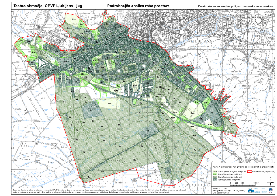
The aim of the task is to verify the method for determining the vulnerability level (damage potential) in flood hazard areas so that it can be used to determine the level of flood risk. According to the Directive, to reduce the adverse impacts of floods it is appropriate to provide for flood risk management plans. These plans should focus on prevention, protection and preparedness, and they should consider the maintenance of existing flood areas as well as measures to prevent and reduce damage to human health, the environment, cultural heritage and economic activity. The Directive further states that the maps of flood risks and maps of flood threats for previously identified areas of significant flood risk should be completed by 22 December 2013. According to Slovenian legislation, the maps of flood risks and maps of flood threats should be produced in line with the Rules, which also sets out the method for preparing these maps and defines the criteria for classifying flood risks into flood risk classes (high, medium and low flood risk classes). This implementing regulation therefore ensures the application of uniform methodology in making the maps of flood risks and threats.
The vulnerability analysis is laid down in the Rules (Article 14) and is produced in order to assess the risks associated with the individual risk elements or groups of risk elements (number of inhabitants, type of economic activity, sources of pollution and areas with special requirements, cultural heritage). However, the vulnerability analysis can, when this is necessary to plan measures or other vital flood risk activities, include a detailed analysis of land use and an assessment of the possible consequences of damage (both indirect and direct damage).
Vulnerability analyses have four vulnerability classes of risk elements (high, medium, low and very low vulnerability class). The vulnerability class is determined using criteria that classify risk elements into groups according to the magnitude and significance of the possible consequences of damage. In accordance with the Rules, flood risk classes are determined using flood risk criteria (Annex V) and depending on the hazard class and vulnerability class of risk elements.
In our task, the vulnerability class criteria were slightly modified and complemented according to the availability of data as referred to in the second paragraph of Article 14 of the Rules. The criteria were complemented in order to provide a more realistic assessment of the vulnerability level of the damage potential. In describing the damage potential, we used data on risk elements that was used to make the preliminary assessment of flood risk (IWRS, 2012).
Our task therefore covers the development of the procedure and description of the method for determining the vulnerability level in order to determine the level of flood risk in areas of significant impact of floods.
In our task, we used a test area of significant impact of floods (Ljubljana-South) to examine the method for determining vulnerability and the method of presenting flood risk in compliance with the Rules. The procedure for determining vulnerability was reviewed and described for a concrete example, and findings were produced for orientation in subsequent tasks associated with flood risk management.
Keywords
About the Project
PROJECT LIBRARY
Photo Gallery
OTHER NATIONAL REFERENCES

Expert bases for determining the priorities of the Republic of Slovenia in the field of environment and efficient use of resources and identification of the themes that are most suitable for co-financing from the LIFE program
In the framework of the project task, we prepared guidelines on the thematic priorities from the Multi-annual LIFE work program for the period 2014–2017 in the priority area Environment and efficient use of resources, and Environmental management and information for Lot 1: water, including the marine environment. The thematic priorities...
Remote sensing of large river hydromorphological characteristics and impact assessment on biotic communities
The project’s aim is to identify and compare impacts of different stressors (hydromorphological alterations, pollution, land use), acting on different spatial scales (reach, segment, catchment), on benthic macroinvertebrate and fish communities in Slovenian large rivers, as well as to analyse the comparability between field survey and remote sensing based hydromorphological...

Monitoring of the river ecosystem on water licence area on the river Soča
In this project our task is to monitor the impact of hydropower plant operation on river Soča ecological status/potential, specifically on biological quality elements, hydrological, and physico-chemical quality elements according to the current legislation.